
The new Ridge to Bridge Marathon course is USATF certified (certificate NC09064-PH). Qualifying times achieved in this race will be eligible for submittal to the BAA for admission into the 2013 and 2014 Boston Marathon.
This information is considered complete and up-to-date as of the date of this writing. As with the best-laid plans of any endeavor, however, it is possible that some details can change. Please check back to this site often for the most current information. You are most strongly encouraged to take one final look on Wednesday, October 19th, as we plan to go with whatever weve got at that time.
WELCOME!
Veteran R2BM'ers and newcomers who joined the Ridge to Bridge family in 2011 were treated to a fabulous day on a wonderful course that passes through the Pisgah National Forest. If you've been here before, it'll be good to have you back. If this would be your first time with us, we would like to take this opportunity to offer a warm welcome. We think you'll like our marathon, and love the National Forest!
CHAMPIONCHIP TIMING & SCORING
Lee Timing LLC (Morganton, NC) will be on-hand to provide net (chip start & finish) chip timing using ChampionChip timing. The timing chips will be single use chips, which means no post-race collection. Your chip is yours to keep as a souvenir. ChampionChip timing chips are worn on the shoe, for more accurate and reliable reads.
DATE & TIME
Saturday, October 27, 2012, 8:00am
The course limit is six hours so please come prepared to cross the finish line by 2:00pm.
THE FIELD
To the folks who bring you the Ridge to Bridge Marathon, two things stand out as the most important: your safety and the quality of your experience here with us, in that order. We believe that a field of 350 people is just about right for the course, and for the limits of our logistical infrastructure, i.e. transportation, accommodations, volunteers, etc. We want you to be safe and we want every aspect of your stay with us to be enjoyable, therefore, we have placed a strict limit of 350 runners on our field. The permit application we submitted for permission to use some of the roads well follow) discloses this number as our maximum number of participants. Once we reach that number of entries, registration will be closed. Please understand that once we have closed registration it is truly closed; it simply wouldnt be fair to accept just one more while turning down another. Please understand and try us again in 2013.
REGISTRATION PROCESS
Registration in 2011 was a big surprise for us: we reached (and exceeded) our cap in about seven hours. Although we would love to accommodate everyone who wishes to join us, we will continue to observe a strict limit of 350 runners: just big enough to ensure a wide range of abilities yet small enough to maintain the peronal touch we feel makes this race a little different.
On line registration will open Friday, June 1 at 12:00pm Eastern time. 300 slots will be available at that time. The remaining slots will be set aside for BMRC members (as of January 1, 2012), past R2BM participants, and two-time volunteers. Set-aside slots will be made available by online entry; wait list entries will be made available by downloadable paper entry from the same site. All add-on entries must be completed/postmarked by July 1, 2012. If you are claiming R2BM veteran runner or club member status we'll verify and hold you to it; if you regsiter online but don't qualify we'll consider your entry fee to be a donation; do not ask for it to be refunded.
ENTRY FEE SCHEDULE
$90.00 while registration remains open. This includes the online registration fee. No race day registration.
WITHDRAWALS & REFUNDS (Available through September 1st only)
Runners who register for the 2012 Ridge to Bridge Marathon may withdraw at any time, for any reason, up to September 1, 2012, and will receive a refund of the entry fee paid, minus a $26.20 administration fee. We are sorry, but refunds will not be available after September 1, and entries paid in 2012 may not be deferred until 2013.
WAIT LIST
We filled up pretty quickly this year, but there's still a chance to gain an entry slot. Heres how the process will work this year:
1. Past R2BM runners and BMRC club members who register on or before July 1st are automatically added to the confirmed list. Here is your link to online registration.
2. A Wait List registration form will be available by download. Print the form, complete it, and send it in with a check made out for the full entry fee of $90 on or before July 1st. Your check will not be immediately deposited; we will hold it until such time as you've been moved onto the confirmed list, if it occurs.
3. Special consideration will be given to those who can commit volunteers to this year's Ridge to Bridge or two other local events. If you can pledge two volunteers, your likelihood of getting in improve dramatically! (Emphasis on "dramatically")
4. Withdrawals will be filled from the Wait List in sequential order.
5. Checks received from those Wait Listers who become confirmed registrants will then be deposited. Should a confirmed entrant wish to withdraw at that point, he or she may be eligible for an entry fee refund as described in the WITHDRAWALS & REFUNDS section above.
6. Wait Listers who remain on the list and do not become confirmed registrants before October 1, 2012 will receive notice and their checks destroyed, along with our apology for not being able to accommodate them this year.
WEATHER CONDITIONS
Sunrise: 7:39am Avg. High: 69°F Avg. Low: 42°F Record High: 85°F Record Low: 22°F
The averages and records listed above are for the Morganton/Lenoir area, which is where the finish line is located. Be aware that the October 27th average low for the Jonas Ridge area is 36°F; the record low is 16°F. In other words, on the average October 27th you can expect a temperature of 36°F at the starting line and 69°F at the finish line.
The temps over the last five years have stayed more or less in this window, although it has been a bit cooler at the start one year, and a bit warmer at the finish another. Weve also experienced some wind and some rain but, all in all, weve not yet experienced a bad weather day for a marathon. Maybe were overdue? Just remember that this marathon takes place in the Blue Ridge Mountains and southern foothills of North Carolina in late October. Virtually anything is possible, so pack accordingly.
PACKET PICKUP
Race packets may be picked up on Friday at the Quality Inn, or at the starting line between 7:00AM and 7:40AM race day. Friday packet pickup will take place from 3:00pm to 9:00pm at the host hotel in Morganton (Please see info for Host Hotel below). Race day packets must be picked up before 7:40AM or yours may not be there when you get there. Please make sure you arrive on time so we can get started promptly at 8:00AM. If you arrive at 7:55AM and your packet is no longer there, please understand that we have to be fair to those who picked up on time and wish to get the race under way.
HOST HOTEL
The host hotel for this year's event is the Quality Inn, located at 2400 South Sterling Street in Morganton. It is conveniently located at I-40 exit 105 and has graciously provided us with plenty of space for packet pickup this year. The negotiated rate is to be determined. Reservations may be made by calling the hotel directly at (828)437-0171 and booking with a valid credit card. Included in the rate is a bagged breakfast that will be available starting at 4:00am on race day. Reservations must be made before September 10th, at which time any remaining rooms will be released and made available at the standard rate. Late checkouts will be available to CHOICE Privileges members (you can sign up for free when you check in) and subject to availability, will allow you to check out as late as 2:00pm on race day.
Other hotel options can be found by following this link. Our $0.02 worth on this one: stick with the brand names.
PARKING & BUS DEPARTURE FOR THIS POINT-TO-POINT COURSE
Runners will park near Brown Mountain Beach Resort, which is located about 45 minutes from Morganton and Lenoir. Due to a shortage of parking in Jonas Ridge we strongly recommend parking in the designated area at Brown Mountain Beach and making use of the transportation provided. Buses will leave promptly at 6:30am and arrive in Jonas Ridge at ~7:15am. The race will start promptly at 8:00am. The finish line is approximately 300 meters from the parking area.
Runners are encouraged to arrive at the bus pickup area by 6:00am to allow sufficient time for last-minute preparation and boarding the buses. Allow 45 minutes travel time by car from either Morganton or Lenoir.
DIRECTIONS TO PARKING & BUS PICKUP
The following directions were lifted from the Brown Mountain Beach Resort web site . You may want to visit the web site yourself just to get a preview of what the area looks like:
Using Interstate 40 West (from Statesville):
·Take Morganton exit 100 and go right onto Jamestown Rd.
·Follow Jamestown Rd until it tees into NC181 (Hardees will be on your right). Turn LEFT.
·Travel 10.2 miles and turn right onto Brown Mountain Beach Rd.
·Travel 5 miles and turn left after concrete bridge onto Brown Mountain Beach Rd.
·Resort is 3/4 mile on left
Using I-85 South/US-321 North/I-40 West (from Charlotte):
·Take I-85 South toward Gastonia/Spartanburg
·Take Exit 17 for US-321 North toward Gastonia/Lincolnton
·Follow US-321 to Exit 43B for I-40 West, toward Asheville
·Take Morganton exit 100 and go right onto Jamestown Rd.
·Follow Jamestown Rd until it tees into NC181 (Hardees will be on your right). Turn LEFT.
·Travel 10.2 miles and turn right onto Brown Mountain Beach Rd.
·Travel 5 miles and turn left after concrete bridge onto Brown Mountain Beach Rd.
·Resort is 3/4 mile on left
Using Interstate 40 East (from Asheville):
·Take Morganton exit 100 and go left onto Jamestown Rd.
·Follow Jamestown Rd until it tees into NC181 (Hardees will be on your right). Turn LEFT.
·Travel 10.2 miles and turn right onto Brown Mountain Beach Rd.
·Travel 5 miles and turn left after concrete bridge onto Brown Mountain Beach Rd.
·Resort is 3/4 mile on left
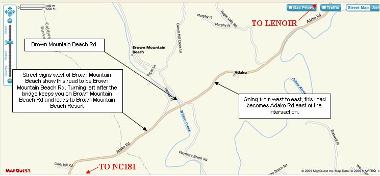
Signs will be posted at the turn to Brown Mountain Beach Rd and to provide directions to the parking area. PLEASE NOTE: Brown Mountain Beach Rd turns into Adako Rd (going from west to east) at the turn-off to Brown Mountain Beach Resort. The turn-off itself is also called Brown Mountain Beach Rd, heading north from the intersection. Please see the map below:
THE START (Get directions to the Start)
As we have in years past, positions at the starting line will be seeded, with the fastest runners at the front. Runners will be seeded based upon marathon PR and expected finish times (please be honest!), with the lowest bib numbers going to the highest seeds. At the starting line, all runners will be asked to look behind them to make sure they are not lined up ahead of someone with a lower number. Chip timing will eliminate any disadvantage (however small) from starting further from the starting line. The purpose of seeding our field is to minimize congestion at the start and give everyone the best possible chance to finish within his or her goal time.
THE COURSE (Click HERE for a USATF course map)
Jonas Ridge to Brown Mountain Beach Resort (Caldwell County, NC). The course starts on Mortimer Road in front of the U.S. Post office, diagonally across NC181 from and Mountain Crossing Mercantile. Starting from the Post Office:
· Follow Mortimer Road, bearing left at Old Jonas Ridge Road (approx 2.5 miles into the run);
· Continue on Old Jonas Ridge until turnaround located approximately 25 meters before the stop sign for the Blue Ridge Parkway;
· Turn back toward the start, bearing left onto the unpaved rad just beyond the white Chuch on your left (approx. 5.5 miles into the run);
· Follow the unpaved road toward Edgemont, turning left onto Edgemont Rd (approx. 14.5 miles into run);
· Follow Edgemont Road north through Edgemont, approximately 250 meters beyond Coffeys General Store to turnaround (approx. 15.5 miles into run);
· Turn back (south) on Edgemont Road to Mortimer. Turn right onto Brown Mountain Beach Road (approx. 18 miles into run);
· Follow Brown Mountain Beach Road for approximately 8 miles;
· Turn right into Brown Mountain Beach Resort to the finish line.
All distances and reference markers noted above are approximate; actual reference marker locations are available on the USATF web site under certified courses. In the meantime, please click here for a link to the course map as submitted and incorporated into the USATF Measurement Certificate. On the map you can clearly find the start, finish, and both out & back locations. The mile markers are referenced on another document which is probably a bit bulky to be posted here but you'll get the general idea. Mile markers will be clearly identified with high visibility signs on race day, as will all of the turns, so we're pretty confident no one will get lost.
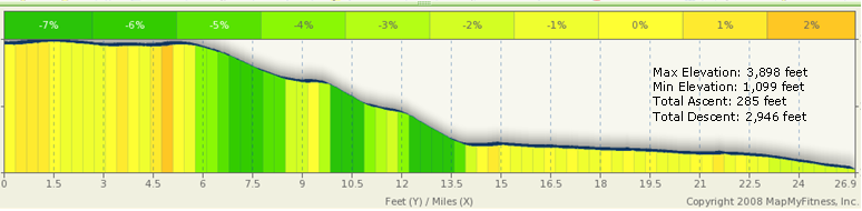
COURSE PROFILE
The Ridge to Bridge course consists of approximately 7 miles of paved surface: approximately 5.5 miles at the start in Jonas Ridge, and a few short stretches in various places along the course, including the last quarter mile or so. R2BM veterans will see the map below and notice some enormous differences, especially the noticeable lack of hills on the back half.
The majority of the course is run on quiet, unpaved country roads that pass through dense forests and open fields, and provide for some outstanding views of the mountains. Camber is not an issue.
The course is not a trail, in any sense of the word, but simply an unpaved road. There can be rocks and sticks that may have fallen from overhanging trees, but there will be no large stones or roots lying in wait to catch the shuffling foot. If you are not accustomed to running downhill on an unpaved surface and you plan to run aggressively, we urge you to be especially careful when negotiating turns. There may be some loose stones in some places and it may be possible to slip if youre not paying attention to what youre doing.
The bottom line: be aware of whats on the course that you might step on, especially as youre entering a turn running downhill. You may just avoid a nasty scrape or two.
The hills on the new course are fewer in number and tend to be less steep, none with a grade of greater than 2%. They also tend to be front-end loaded, with the more noticeable rises appearing within the first 1.5 miles (~ 20 meters of climb over the distance), and from mile 4.7 - 5.6 (~ 15.5 meters). Further along the course, you may expect two more modest rises: mile 9.6 - 9.8 (~ 3 meters) and mile 15.0 - 15.7 (~ 7.5 meters); and a bump in the road at mile 21.7 - 21.9 (~ 2 meters).
All of these little rises can be quickly identified on the profile map (below) as gold and orange vertical bands. For example, the orange vertical band that appears just to the right of the 4.5 mark on the X-axis correlates with the roughly 15.5 meters of climb between mile 4.7 and mile 5.6. It also happens to be the only orange vertical band on the graph, indicating that at a 2% grade, it is the steepest section on the course. To put this into context, Zion Hill on the old Ridge to Bridge course climbs approximately 300 feet over a space of just over a mile with 4-5% grades over the span.
A quick glance at the yellow, light green, and dark green vertical bands reveals how much of the course is either flat or descending; the darker the green, the steeper the descent.
TRAFFIC CONDITIONS
Traffic on Saturday mornings at 8:00am in Jonas Ridge is usually very light. Its possible well see a handful of cars over the first 5.5 miles, after which we might see another dozen or so on the way to Brown Mountain Beach Resort. None of the roads we will be using will be closed on race day; we will share them with the small number of cars were likely to encounter along the way. Please be courteous: smile, wave, and then get out of the way. Do not run left of the center line; be safe and stay to the right of the roadway. Any runner who fails to yield the proper right of way to vehicles may be disqualified. This is non-negotiable; cars & trucks weigh a lot more than runners and require a lot more room to stop. Play it safe: stay to the right and remain aware of your surroundings at all times.
COURSE SURFACE
Please allow these photos to end any speculation as to whether or not the New Ridge to Bridge course resembles a trail. And as long as Im adding some photos, Ill include some extras so you can familiarize yourself with some of the scenery ahead of time. (NOTE: none of the photos were taken in the fall, so use your imagination!) Click on each photo for a larger view.
PROPER DISPOSAL OF TRASH
Trash bins will be placed approximately 50 meters down the course from each aid station. It is your responsibility to hang onto your trash (including gel packets) until it can be properly disposed.
Cleaning up after ourselves is of paramount importance, not just because its the law, but its also the right thing to do. After all, for most of the run well be enjoying some beautiful scenery that should at all costs be preserved for future generations.
Please - dont litter. We really dont want to have to disqualify anyone and possibly bar them from future entry. After all, we believe that if one is tough enough to run a marathon, one should be strong enough to carry a gel packet until the next trash bin. Lets be kind and leave only our footprints behind.
HEAD PHONES
As many of you know, USATF changed its stance on head phones earlier in 2009. Many events, including this one, no longer enforce a ban on their use.
Having said that, we are obliged to ask you to consider this: one cannot avoid what one cannot see or hear. Not wearing head phones (or only listening to one ear bud) is safer for you and more courteous to your fellow runners. PLEASE REMOVE YOUR EARPIECES BEFORE ENTERING THE FINISH AREA!
AID STATIONS
Aid stations will be stocked with Ice River Springs water and sports drink at the following approximate locations along the course: Mile 2.4; 5.7 (same location as 2.4); 8.25; 11.25; 13.1; 15/16 (same location); 18.5; 21; 23.2; and 25. GU energy gel will be available at mile 13.1, 18.5, and 21. Enhancements to the aid stations may be made between now and race day. Your suggestions are, of course, welcome. Sorry, no Moon Pies or pork rinds.
LOST & FOUND
Extra articles of clothing you'd like to shed may be left with us at the start or at the Mile 2.4/5.7 and Mile 8.25 Aid Stations. These articles will be taken to the finish area for pickup when you arrive, or shortly thereafter. Articles left at other aid stations will also be taken to the finish area but may or may not be available when you get there. If you leave something with us you'd like to have back, please stay until the volunteers from that aid station arrive. Articles not collected before we leave for the day (approximately 2:30pm) will be donated to a suitable charity if not claimed with 7 days of the race.
TOILETS
Restroom facilities will be available at the start. Portable restroom facilities will be placed near Edgemont, a mile or so beyond the half way point. Fixed facilities are also available at Mortimer Campground (~ mile 18), the Visitor Center (~ mile 21), and a few odd places in between.
AWARDS
Awards will be presented to the top three overall males and females, top male and female masters (40+), and the top three males and females in each of the following age groups: 19 and under; 20-24; 25-29; 30-34; 35-39; 40-44; 45-49; 50-54; 55-59; 60-64; 65-69; 70-74; and 75 & over. Award winners must be present at the awards ceremony; no prizes will be sent by mail. Special recognition will be posted to our web site for those participants who attempt and succeed in qualifying for the Boston Marathon.
DROPPING OUT OF THE RACE
Everyone has a bad day now and then, and flying down a 2,700 foot descent increases the chances that October 27th might be your bad day (although we hope not!). If you find yourself more uncomfortable than youre accustomed to in a marathon we encourage you to think carefully about whether or not you really ought to continue. Wed much rather see you pull out before a serious injury so that you will be in a better position to join us again next year. Please, dont hurt yourself; one race simply isnt worth it. Well see to it that you have a ride back to your car.
A WORD REGARDING RACE BANDITS
Most runners will agree that the practice of participating in a race for which you have neither entered nor paid the entry fee is inherently discourteous to those who have. Please -- if you havent registered please do not take for yourself that which others have paid for. If you havent registered but you still really want to get in on the marathon experience, please contact the BMRC and offer yourself as a volunteer; wed be glad to have your help!
A FINAL THOUGHT REGARDING RACE STRATEGY
There is no such thing as a gimme marathon course. 26.2 miles is a long way to run no matter how the course is laid out. Please accept this advice from those who really, really want to see you do well.
The first 10 kilometers of the course might best be described as a rolling 10K. Much of it is flat or slightly downhill, while there are some sections (the first 1.5 miles, 3.6-3.8, and 4.7-5.6) that offer modest climbs. As noted in the COURSE PROFILE section, 4.7-5.6 may well be the steepest grade on the course. The best use of this upper section is to establish a comfortable pace and take advantage of the warm-up to be better prepared to start the descent toward Edgemont.
The nine miles between Mortimer Road and Edgemont Road offer the longest, sustained downhill sections on the course. Although one might be tempted to put some time in the bank by flying down the hill, it is far better to take a more conservative approach. A downhill grade offers three things: (1) an opportunity to go very fast; (2) an opportunity to conserve energy; and (3) a combination of the two. Pursuing the first choice can actually be the worst of all three; the wear and tear on the quads and calves can be devastating, especially to those who encounter little or no hills in their daily routine. Instead of blowing it out, run the first 15-16 miles comfortably, maybe only 5-15 seconds per mile faster than youd ordinarily run a goal marathon. The result is that youll save yourself a lot of unnecessary wear and tear, and youll probably have a lot more gas in the tank than youre accustomed to having over the last six to eight miles of a marathon. This is where your first-half strategy will have the greatest impact. Keep this in mind as well: the last 8 miles of this marathon course is an almost uninterrupted descent of about 500 feet. If you reach this section on track and you didnt overdo it over the first 18, you will be in an outstanding position to reach - or exceed - your goal.
In summary:
Miles 1-6: Run comfortably within yourself here. Your early-miles adrenaline will carry you through but dont be tempted to overdo it. Take your goal time and break it up into 26.2 equal bites (your pace per mile). Dont worry if you find yourself 10 seconds per mile behind goal pace over the first six miles. Youll easily make this up over the next nine miles with no additional effort. Stay calm, conserve your energy, and remain comfortable.
Miles 6-16: The big drop begins at about mile 6 and continues through about mile 14 with only one rise at about mile ten. Keep an eye on your watch to make sure youre not running too quickly over this section. Averaging even 10-15 seconds below goal pace is running more aggressively than necessary. One can easily go much faster at various points in this section; the hard part is resisting the urge to do so.
Mile 17- 26.2: After the slight climb between Edgemont and Mortimer at about mile 17, the rest of the course is a long, steady descent along Wilson Creek. In all, the course drops about 500 feet over this section. If youve run comfortably and conserved energy over the first 18 miles, and you get there reasonably close to your target time, you will be in the best possible position to finish within your goal time. Take advantage of the extra fuel in your tank and consider stepping up the pace a bit if you still feel comfortable after mile 22 or 23. Well be waiting for you. Enjoy.
FOR MORE INFORMATION AND USEFUL TIPS
Visit the BMRC Message Boards regularly. There youll find questions posted by others like you, advice from the organizers and BMRC members, and tips from others who have come to the area to run, sightsee, and play. New thoughts and ideas are posted virtually every day, so stay tuned. There just might be something in there thats useful to you on race day!
This information is considered complete and up-to-date as of the date of this writing. As with the best-laid plans of any endeavor, however, it is possible that some details can change. Please check back to this site often for the most current information. You are most strongly encouraged to take one final look on Wednesday, October 19th, as we plan to go with whatever weve got at that time.
WELCOME!
Veteran R2BM'ers and newcomers who joined the Ridge to Bridge family in 2011 were treated to a fabulous day on a wonderful course that passes through the Pisgah National Forest. If you've been here before, it'll be good to have you back. If this would be your first time with us, we would like to take this opportunity to offer a warm welcome. We think you'll like our marathon, and love the National Forest!
CHAMPIONCHIP TIMING & SCORING
Lee Timing LLC (Morganton, NC) will be on-hand to provide net (chip start & finish) chip timing using ChampionChip timing. The timing chips will be single use chips, which means no post-race collection. Your chip is yours to keep as a souvenir. ChampionChip timing chips are worn on the shoe, for more accurate and reliable reads.
DATE & TIME
Saturday, October 27, 2012, 8:00am
The course limit is six hours so please come prepared to cross the finish line by 2:00pm.
THE FIELD
To the folks who bring you the Ridge to Bridge Marathon, two things stand out as the most important: your safety and the quality of your experience here with us, in that order. We believe that a field of 350 people is just about right for the course, and for the limits of our logistical infrastructure, i.e. transportation, accommodations, volunteers, etc. We want you to be safe and we want every aspect of your stay with us to be enjoyable, therefore, we have placed a strict limit of 350 runners on our field. The permit application we submitted for permission to use some of the roads well follow) discloses this number as our maximum number of participants. Once we reach that number of entries, registration will be closed. Please understand that once we have closed registration it is truly closed; it simply wouldnt be fair to accept just one more while turning down another. Please understand and try us again in 2013.
REGISTRATION PROCESS
Registration in 2011 was a big surprise for us: we reached (and exceeded) our cap in about seven hours. Although we would love to accommodate everyone who wishes to join us, we will continue to observe a strict limit of 350 runners: just big enough to ensure a wide range of abilities yet small enough to maintain the peronal touch we feel makes this race a little different.
On line registration will open Friday, June 1 at 12:00pm Eastern time. 300 slots will be available at that time. The remaining slots will be set aside for BMRC members (as of January 1, 2012), past R2BM participants, and two-time volunteers. Set-aside slots will be made available by online entry; wait list entries will be made available by downloadable paper entry from the same site. All add-on entries must be completed/postmarked by July 1, 2012. If you are claiming R2BM veteran runner or club member status we'll verify and hold you to it; if you regsiter online but don't qualify we'll consider your entry fee to be a donation; do not ask for it to be refunded.
ENTRY FEE SCHEDULE
$90.00 while registration remains open. This includes the online registration fee. No race day registration.
WITHDRAWALS & REFUNDS (Available through September 1st only)
Runners who register for the 2012 Ridge to Bridge Marathon may withdraw at any time, for any reason, up to September 1, 2012, and will receive a refund of the entry fee paid, minus a $26.20 administration fee. We are sorry, but refunds will not be available after September 1, and entries paid in 2012 may not be deferred until 2013.
WAIT LIST
We filled up pretty quickly this year, but there's still a chance to gain an entry slot. Heres how the process will work this year:
1. Past R2BM runners and BMRC club members who register on or before July 1st are automatically added to the confirmed list. Here is your link to online registration.
2. A Wait List registration form will be available by download. Print the form, complete it, and send it in with a check made out for the full entry fee of $90 on or before July 1st. Your check will not be immediately deposited; we will hold it until such time as you've been moved onto the confirmed list, if it occurs.
3. Special consideration will be given to those who can commit volunteers to this year's Ridge to Bridge or two other local events. If you can pledge two volunteers, your likelihood of getting in improve dramatically! (Emphasis on "dramatically")
4. Withdrawals will be filled from the Wait List in sequential order.
5. Checks received from those Wait Listers who become confirmed registrants will then be deposited. Should a confirmed entrant wish to withdraw at that point, he or she may be eligible for an entry fee refund as described in the WITHDRAWALS & REFUNDS section above.
6. Wait Listers who remain on the list and do not become confirmed registrants before October 1, 2012 will receive notice and their checks destroyed, along with our apology for not being able to accommodate them this year.
WEATHER CONDITIONS
Sunrise: 7:39am Avg. High: 69°F Avg. Low: 42°F Record High: 85°F Record Low: 22°F
The averages and records listed above are for the Morganton/Lenoir area, which is where the finish line is located. Be aware that the October 27th average low for the Jonas Ridge area is 36°F; the record low is 16°F. In other words, on the average October 27th you can expect a temperature of 36°F at the starting line and 69°F at the finish line.
The temps over the last five years have stayed more or less in this window, although it has been a bit cooler at the start one year, and a bit warmer at the finish another. Weve also experienced some wind and some rain but, all in all, weve not yet experienced a bad weather day for a marathon. Maybe were overdue? Just remember that this marathon takes place in the Blue Ridge Mountains and southern foothills of North Carolina in late October. Virtually anything is possible, so pack accordingly.
PACKET PICKUP
Race packets may be picked up on Friday at the Quality Inn, or at the starting line between 7:00AM and 7:40AM race day. Friday packet pickup will take place from 3:00pm to 9:00pm at the host hotel in Morganton (Please see info for Host Hotel below). Race day packets must be picked up before 7:40AM or yours may not be there when you get there. Please make sure you arrive on time so we can get started promptly at 8:00AM. If you arrive at 7:55AM and your packet is no longer there, please understand that we have to be fair to those who picked up on time and wish to get the race under way.
HOST HOTEL
The host hotel for this year's event is the Quality Inn, located at 2400 South Sterling Street in Morganton. It is conveniently located at I-40 exit 105 and has graciously provided us with plenty of space for packet pickup this year. The negotiated rate is to be determined. Reservations may be made by calling the hotel directly at (828)437-0171 and booking with a valid credit card. Included in the rate is a bagged breakfast that will be available starting at 4:00am on race day. Reservations must be made before September 10th, at which time any remaining rooms will be released and made available at the standard rate. Late checkouts will be available to CHOICE Privileges members (you can sign up for free when you check in) and subject to availability, will allow you to check out as late as 2:00pm on race day.
Other hotel options can be found by following this link. Our $0.02 worth on this one: stick with the brand names.
PARKING & BUS DEPARTURE FOR THIS POINT-TO-POINT COURSE
Runners will park near Brown Mountain Beach Resort, which is located about 45 minutes from Morganton and Lenoir. Due to a shortage of parking in Jonas Ridge we strongly recommend parking in the designated area at Brown Mountain Beach and making use of the transportation provided. Buses will leave promptly at 6:30am and arrive in Jonas Ridge at ~7:15am. The race will start promptly at 8:00am. The finish line is approximately 300 meters from the parking area.
Runners are encouraged to arrive at the bus pickup area by 6:00am to allow sufficient time for last-minute preparation and boarding the buses. Allow 45 minutes travel time by car from either Morganton or Lenoir.
DIRECTIONS TO PARKING & BUS PICKUP
The following directions were lifted from the Brown Mountain Beach Resort web site . You may want to visit the web site yourself just to get a preview of what the area looks like:
Using Interstate 40 West (from Statesville):
·Take Morganton exit 100 and go right onto Jamestown Rd.
·Follow Jamestown Rd until it tees into NC181 (Hardees will be on your right). Turn LEFT.
·Travel 10.2 miles and turn right onto Brown Mountain Beach Rd.
·Travel 5 miles and turn left after concrete bridge onto Brown Mountain Beach Rd.
·Resort is 3/4 mile on left
Using I-85 South/US-321 North/I-40 West (from Charlotte):
·Take I-85 South toward Gastonia/Spartanburg
·Take Exit 17 for US-321 North toward Gastonia/Lincolnton
·Follow US-321 to Exit 43B for I-40 West, toward Asheville
·Take Morganton exit 100 and go right onto Jamestown Rd.
·Follow Jamestown Rd until it tees into NC181 (Hardees will be on your right). Turn LEFT.
·Travel 10.2 miles and turn right onto Brown Mountain Beach Rd.
·Travel 5 miles and turn left after concrete bridge onto Brown Mountain Beach Rd.
·Resort is 3/4 mile on left
Using Interstate 40 East (from Asheville):
·Take Morganton exit 100 and go left onto Jamestown Rd.
·Follow Jamestown Rd until it tees into NC181 (Hardees will be on your right). Turn LEFT.
·Travel 10.2 miles and turn right onto Brown Mountain Beach Rd.
·Travel 5 miles and turn left after concrete bridge onto Brown Mountain Beach Rd.
·Resort is 3/4 mile on left
Signs will be posted at the turn to Brown Mountain Beach Rd and to provide directions to the parking area. PLEASE NOTE: Brown Mountain Beach Rd turns into Adako Rd (going from west to east) at the turn-off to Brown Mountain Beach Resort. The turn-off itself is also called Brown Mountain Beach Rd, heading north from the intersection. Please see the map below:
THE START (Get directions to the Start)
As we have in years past, positions at the starting line will be seeded, with the fastest runners at the front. Runners will be seeded based upon marathon PR and expected finish times (please be honest!), with the lowest bib numbers going to the highest seeds. At the starting line, all runners will be asked to look behind them to make sure they are not lined up ahead of someone with a lower number. Chip timing will eliminate any disadvantage (however small) from starting further from the starting line. The purpose of seeding our field is to minimize congestion at the start and give everyone the best possible chance to finish within his or her goal time.
THE COURSE (Click HERE for a USATF course map)
Jonas Ridge to Brown Mountain Beach Resort (Caldwell County, NC). The course starts on Mortimer Road in front of the U.S. Post office, diagonally across NC181 from and Mountain Crossing Mercantile. Starting from the Post Office:
· Follow Mortimer Road, bearing left at Old Jonas Ridge Road (approx 2.5 miles into the run);
· Continue on Old Jonas Ridge until turnaround located approximately 25 meters before the stop sign for the Blue Ridge Parkway;
· Turn back toward the start, bearing left onto the unpaved rad just beyond the white Chuch on your left (approx. 5.5 miles into the run);
· Follow the unpaved road toward Edgemont, turning left onto Edgemont Rd (approx. 14.5 miles into run);
· Follow Edgemont Road north through Edgemont, approximately 250 meters beyond Coffeys General Store to turnaround (approx. 15.5 miles into run);
· Turn back (south) on Edgemont Road to Mortimer. Turn right onto Brown Mountain Beach Road (approx. 18 miles into run);
· Follow Brown Mountain Beach Road for approximately 8 miles;
· Turn right into Brown Mountain Beach Resort to the finish line.
All distances and reference markers noted above are approximate; actual reference marker locations are available on the USATF web site under certified courses. In the meantime, please click here for a link to the course map as submitted and incorporated into the USATF Measurement Certificate. On the map you can clearly find the start, finish, and both out & back locations. The mile markers are referenced on another document which is probably a bit bulky to be posted here but you'll get the general idea. Mile markers will be clearly identified with high visibility signs on race day, as will all of the turns, so we're pretty confident no one will get lost.
COURSE PROFILE
The Ridge to Bridge course consists of approximately 7 miles of paved surface: approximately 5.5 miles at the start in Jonas Ridge, and a few short stretches in various places along the course, including the last quarter mile or so. R2BM veterans will see the map below and notice some enormous differences, especially the noticeable lack of hills on the back half.
The majority of the course is run on quiet, unpaved country roads that pass through dense forests and open fields, and provide for some outstanding views of the mountains. Camber is not an issue.
The course is not a trail, in any sense of the word, but simply an unpaved road. There can be rocks and sticks that may have fallen from overhanging trees, but there will be no large stones or roots lying in wait to catch the shuffling foot. If you are not accustomed to running downhill on an unpaved surface and you plan to run aggressively, we urge you to be especially careful when negotiating turns. There may be some loose stones in some places and it may be possible to slip if youre not paying attention to what youre doing.
The bottom line: be aware of whats on the course that you might step on, especially as youre entering a turn running downhill. You may just avoid a nasty scrape or two.
The hills on the new course are fewer in number and tend to be less steep, none with a grade of greater than 2%. They also tend to be front-end loaded, with the more noticeable rises appearing within the first 1.5 miles (~ 20 meters of climb over the distance), and from mile 4.7 - 5.6 (~ 15.5 meters). Further along the course, you may expect two more modest rises: mile 9.6 - 9.8 (~ 3 meters) and mile 15.0 - 15.7 (~ 7.5 meters); and a bump in the road at mile 21.7 - 21.9 (~ 2 meters).
All of these little rises can be quickly identified on the profile map (below) as gold and orange vertical bands. For example, the orange vertical band that appears just to the right of the 4.5 mark on the X-axis correlates with the roughly 15.5 meters of climb between mile 4.7 and mile 5.6. It also happens to be the only orange vertical band on the graph, indicating that at a 2% grade, it is the steepest section on the course. To put this into context, Zion Hill on the old Ridge to Bridge course climbs approximately 300 feet over a space of just over a mile with 4-5% grades over the span.
A quick glance at the yellow, light green, and dark green vertical bands reveals how much of the course is either flat or descending; the darker the green, the steeper the descent.
TRAFFIC CONDITIONS
Traffic on Saturday mornings at 8:00am in Jonas Ridge is usually very light. Its possible well see a handful of cars over the first 5.5 miles, after which we might see another dozen or so on the way to Brown Mountain Beach Resort. None of the roads we will be using will be closed on race day; we will share them with the small number of cars were likely to encounter along the way. Please be courteous: smile, wave, and then get out of the way. Do not run left of the center line; be safe and stay to the right of the roadway. Any runner who fails to yield the proper right of way to vehicles may be disqualified. This is non-negotiable; cars & trucks weigh a lot more than runners and require a lot more room to stop. Play it safe: stay to the right and remain aware of your surroundings at all times.
COURSE SURFACE
Please allow these photos to end any speculation as to whether or not the New Ridge to Bridge course resembles a trail. And as long as Im adding some photos, Ill include some extras so you can familiarize yourself with some of the scenery ahead of time. (NOTE: none of the photos were taken in the fall, so use your imagination!) Click on each photo for a larger view.
PROPER DISPOSAL OF TRASH
Trash bins will be placed approximately 50 meters down the course from each aid station. It is your responsibility to hang onto your trash (including gel packets) until it can be properly disposed.
Cleaning up after ourselves is of paramount importance, not just because its the law, but its also the right thing to do. After all, for most of the run well be enjoying some beautiful scenery that should at all costs be preserved for future generations.
Please - dont litter. We really dont want to have to disqualify anyone and possibly bar them from future entry. After all, we believe that if one is tough enough to run a marathon, one should be strong enough to carry a gel packet until the next trash bin. Lets be kind and leave only our footprints behind.
HEAD PHONES
As many of you know, USATF changed its stance on head phones earlier in 2009. Many events, including this one, no longer enforce a ban on their use.
Having said that, we are obliged to ask you to consider this: one cannot avoid what one cannot see or hear. Not wearing head phones (or only listening to one ear bud) is safer for you and more courteous to your fellow runners. PLEASE REMOVE YOUR EARPIECES BEFORE ENTERING THE FINISH AREA!
AID STATIONS
Aid stations will be stocked with Ice River Springs water and sports drink at the following approximate locations along the course: Mile 2.4; 5.7 (same location as 2.4); 8.25; 11.25; 13.1; 15/16 (same location); 18.5; 21; 23.2; and 25. GU energy gel will be available at mile 13.1, 18.5, and 21. Enhancements to the aid stations may be made between now and race day. Your suggestions are, of course, welcome. Sorry, no Moon Pies or pork rinds.
LOST & FOUND
Extra articles of clothing you'd like to shed may be left with us at the start or at the Mile 2.4/5.7 and Mile 8.25 Aid Stations. These articles will be taken to the finish area for pickup when you arrive, or shortly thereafter. Articles left at other aid stations will also be taken to the finish area but may or may not be available when you get there. If you leave something with us you'd like to have back, please stay until the volunteers from that aid station arrive. Articles not collected before we leave for the day (approximately 2:30pm) will be donated to a suitable charity if not claimed with 7 days of the race.
TOILETS
Restroom facilities will be available at the start. Portable restroom facilities will be placed near Edgemont, a mile or so beyond the half way point. Fixed facilities are also available at Mortimer Campground (~ mile 18), the Visitor Center (~ mile 21), and a few odd places in between.
AWARDS
Awards will be presented to the top three overall males and females, top male and female masters (40+), and the top three males and females in each of the following age groups: 19 and under; 20-24; 25-29; 30-34; 35-39; 40-44; 45-49; 50-54; 55-59; 60-64; 65-69; 70-74; and 75 & over. Award winners must be present at the awards ceremony; no prizes will be sent by mail. Special recognition will be posted to our web site for those participants who attempt and succeed in qualifying for the Boston Marathon.
DROPPING OUT OF THE RACE
Everyone has a bad day now and then, and flying down a 2,700 foot descent increases the chances that October 27th might be your bad day (although we hope not!). If you find yourself more uncomfortable than youre accustomed to in a marathon we encourage you to think carefully about whether or not you really ought to continue. Wed much rather see you pull out before a serious injury so that you will be in a better position to join us again next year. Please, dont hurt yourself; one race simply isnt worth it. Well see to it that you have a ride back to your car.
A WORD REGARDING RACE BANDITS
Most runners will agree that the practice of participating in a race for which you have neither entered nor paid the entry fee is inherently discourteous to those who have. Please -- if you havent registered please do not take for yourself that which others have paid for. If you havent registered but you still really want to get in on the marathon experience, please contact the BMRC and offer yourself as a volunteer; wed be glad to have your help!
A FINAL THOUGHT REGARDING RACE STRATEGY
There is no such thing as a gimme marathon course. 26.2 miles is a long way to run no matter how the course is laid out. Please accept this advice from those who really, really want to see you do well.
The first 10 kilometers of the course might best be described as a rolling 10K. Much of it is flat or slightly downhill, while there are some sections (the first 1.5 miles, 3.6-3.8, and 4.7-5.6) that offer modest climbs. As noted in the COURSE PROFILE section, 4.7-5.6 may well be the steepest grade on the course. The best use of this upper section is to establish a comfortable pace and take advantage of the warm-up to be better prepared to start the descent toward Edgemont.
The nine miles between Mortimer Road and Edgemont Road offer the longest, sustained downhill sections on the course. Although one might be tempted to put some time in the bank by flying down the hill, it is far better to take a more conservative approach. A downhill grade offers three things: (1) an opportunity to go very fast; (2) an opportunity to conserve energy; and (3) a combination of the two. Pursuing the first choice can actually be the worst of all three; the wear and tear on the quads and calves can be devastating, especially to those who encounter little or no hills in their daily routine. Instead of blowing it out, run the first 15-16 miles comfortably, maybe only 5-15 seconds per mile faster than youd ordinarily run a goal marathon. The result is that youll save yourself a lot of unnecessary wear and tear, and youll probably have a lot more gas in the tank than youre accustomed to having over the last six to eight miles of a marathon. This is where your first-half strategy will have the greatest impact. Keep this in mind as well: the last 8 miles of this marathon course is an almost uninterrupted descent of about 500 feet. If you reach this section on track and you didnt overdo it over the first 18, you will be in an outstanding position to reach - or exceed - your goal.
In summary:
Miles 1-6: Run comfortably within yourself here. Your early-miles adrenaline will carry you through but dont be tempted to overdo it. Take your goal time and break it up into 26.2 equal bites (your pace per mile). Dont worry if you find yourself 10 seconds per mile behind goal pace over the first six miles. Youll easily make this up over the next nine miles with no additional effort. Stay calm, conserve your energy, and remain comfortable.
Miles 6-16: The big drop begins at about mile 6 and continues through about mile 14 with only one rise at about mile ten. Keep an eye on your watch to make sure youre not running too quickly over this section. Averaging even 10-15 seconds below goal pace is running more aggressively than necessary. One can easily go much faster at various points in this section; the hard part is resisting the urge to do so.
Mile 17- 26.2: After the slight climb between Edgemont and Mortimer at about mile 17, the rest of the course is a long, steady descent along Wilson Creek. In all, the course drops about 500 feet over this section. If youve run comfortably and conserved energy over the first 18 miles, and you get there reasonably close to your target time, you will be in the best possible position to finish within your goal time. Take advantage of the extra fuel in your tank and consider stepping up the pace a bit if you still feel comfortable after mile 22 or 23. Well be waiting for you. Enjoy.
FOR MORE INFORMATION AND USEFUL TIPS
Visit the BMRC Message Boards regularly. There youll find questions posted by others like you, advice from the organizers and BMRC members, and tips from others who have come to the area to run, sightsee, and play. New thoughts and ideas are posted virtually every day, so stay tuned. There just might be something in there thats useful to you on race day!
COURSE RECORDS
Male Open: Tomasz Kochanowicz, 2:39.13 (2012)
Female Open: Tracy Brooks, 2:53:12 (2011)
Male Masters: Mark Lundblad, 2:44:01 (2010)
Female Masters: Annette Bednosky, 3:09:40 (2009)
Male Open: Tomasz Kochanowicz, 2:39.13 (2012)
Female Open: Tracy Brooks, 2:53:12 (2011)
Male Masters: Mark Lundblad, 2:44:01 (2010)
Female Masters: Annette Bednosky, 3:09:40 (2009)


Ridge to Bridge Marathon 2012
Jonas Ridge to Brown Mountain Beach, NC
GENERAL INFORMATION
(as of October 9, 2012)
|
|
|
|
|


Copyright 2006-2011 Brown Mountain Running Club, Inc. All rights reserved.
Want to learn more and see more photos of the area? Click here to visit the Friends of Wilson Creek web site.
|
|
|
|
|